
The announcement by the Municipality of Elis regarding its collaboration with the Austrian Archaeological Institute and the University of Graz is undoubtedly a highly positive development for archaeological research in the region. Following a challenging winter during which the archaeological site of Elis was at the center of several negative press reports due to flooding caused by heavy rainfall, the news of systematic airborne ground mapping using LiDAR technology represents a clear step forward.
The high-precision airborne mapping is expected to create, for the first time, a unified digital topographical and archaeological grid covering 117 hectares of the ancient city and its surroundings. This constitutes a invaluable database upon which any future planning for scientific research, protection, and heritage enhancement of the site can be grounded.
This development deserves to be welcomed. At the same time, however, it is equally crucial that it be presented with scientific accuracy and without exaggerations, so that realistic expectations are formed for the phases that are set to follow.

LIDAR survey conducted with a Yellowscan LIDAR in November 2015, Belgium. Source: Wikipedia
The Global and Domestic Impact of LiDAR Technology
In recent years, LiDAR (Light Detection and Ranging) technology has fundamentally transformed the way archaeologists approach entire cultural landscapes. Its capacity to map terrain morphology with exceptional precision, even under dense vegetation, allows for the detection of remains that have remained invisible for decades.
- Angkor Wat, Cambodia: Airborne LiDAR scans revealed an extensive and previously unseen urban landscape with networks of roads, canals, reservoirs, embankments, and residential infrastructure. The new data overturned the older perception that Angkor was limited to the large monumental complexes, proving instead that it constituted a massive, complex urban-hydrological system of medieval Southeast Asia.
- Campeche, Mexico (2024): The analysis of airborne LiDAR data brought to light the true extent of the previously unknown Maya urban complex Valeriana, where thousands of structures, pyramids, plazas, ceremonial sites, and water management infrastructures were identified. The discovery demonstrated once again that major portions of ancient cultural landscapes can remain hidden beneath dense tropical canopies.
- The Mediterranean & Greece: The utilization of LiDAR technology, combined with on-site archaeological observations, has proven particularly effective in the Mediterranean. A characteristic example is the case of Ancient Colophon in Ionia, where archaeological remains beneath dense Mediterranean brushwood were detected and documented. Furthermore, in May 2021, a LiDAR survey was conducted in Boeotia by the French School at Athens at two locations: the sanctuary of the Valley of the Muses near Thespiae, and the urban center of Akraiphia.
If the application of this technology at Ancient Elis yields similarly significant data, the benefit will be twofold: on one hand, it will enrich scientific knowledge regarding the topography of the ancient city; on the other, it will allow for a far more targeted design of future excavational research. This prospect alone is enough for us to welcome the new initiative with genuine optimism.
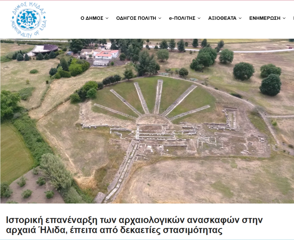
The Title of the Press Release: A Matter of Scientific Accuracy
It is precisely at this point that the core issue with the Municipality’s announcement arises. The title speaks of a “historic resumption of archaeological excavations,” whereas the approved program pertains exclusively to airborne mapping utilizing LiDAR technology for the creation of a digital topographical and archaeological grid.
The relevant permit issued by the Directorate of Prehistoric and Classical Antiquities (ADA: 6ΝΙ046ΝΚΟΤ-ΥΙ3) is absolutely clear:
- It provides for the execution of an airborne scan over an area of 117 hectares for a duration of five years, under the supervision of the Ephorate of Antiquities (EFA) of Ilia.
- It mandates the submission of a detailed scientific report upon the completion of the works.
- It explicitly binds the stakeholders to a prior written notification of the competent services before any public announcement of the results to the media or the internet.
These facts demonstrate that we are dealing with a preparatory stage of scientific research—indispensable, certainly, but entirely distinct from the commencement of an excavational project.
This distinction is by no means a pedantic detail. Between data collection and the actual “first strike of the trowel,” there lie successive, time-consuming phases: data processing, evaluation of potential targets, on-site ground-truthing of indications, and, ultimately, the strategic planning of specific excavation trenches. If the excavation phase were indeed mature, one would expect the presentation of elements such as a projected budget, the source of funding, and an indicative implementation timetable—elements which, for the time being, are entirely absent.